Internationale Partnersuche
Innovation & Technologie Angebot
Light Mapping for efficient placement of public lighting
Country of Origin: Germany
Reference Number: TODE20180605001
Publication Date: 11 June 2018
Summary
A German SME specialized in the processing of space and airborne data with regard to energy applications has developed a technology which uses aerial night images to map public lighting. Advantages include energy savings, more safety for badly lit areas and the decrease of light pollution in overexposed areas. Municipalities, policy makers and service providers are sought for commercial agreements with technical assistance. Partners for EU-funded projects are sought for research agreements.
Description
Street lights consume an enormous amount of energy. A city or municipality therefore can benefit from an efficient use and placement of public lighting and avoid light pollution. A city or municipality therefore can benefit from an efficient use and placement of public lighting. On the other hand it is interesting for cities to know, where public places are badly lit, which could result in a higher number of crime facts or dangerous traffic situations at these locations.
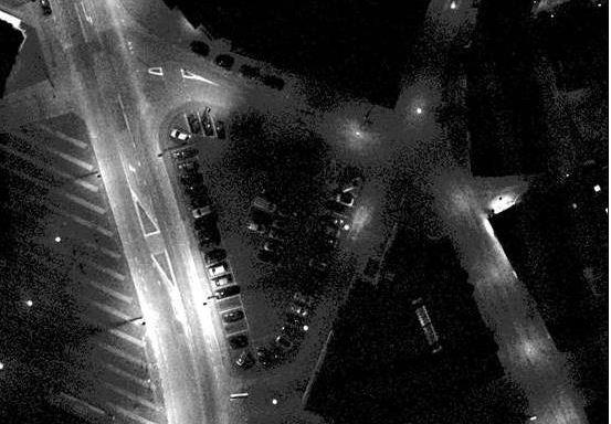
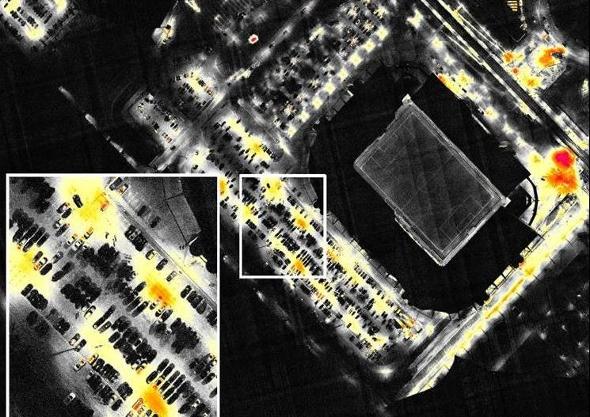
A German SME specialized in the processing of space and airborne data and aerial thermography has developed methods which can be used by public policy makers to tackle these problems. During a night flight aerial imagery with a light sensitive camera is acquired. These “night images” are processed in the same photogrammetric production chain as “day images”, resulting in a detailed “night orthophoto” and light maps. The map is calibrated using luminance measurements executed on the terrain and a legend in absolute luminance values in Candela/m² is created.
Light maps showing the amount of light are an important policy instrument for cities and municipalities with regard to:
- Energy saving: locating excessive or inefficient lighting and potential savings;
- Safety: locating poorly lit areas, which may lead to increased crime and/or traffic hazard;
- Light pollution: pinpoint overexposed areas by both private and public lighting elements.
To allow policy makers to easily interpret the maps, the German SME usually creates two kinds of maps based on the European guidelines for public lighting (EN 13201): the “overexposure map” and the “EN classification map”. On request it can also create other related maps. The “overexposure map” indicates overexposed areas in colour, as well as the European public lighting classes in grey values. The “EN classification map” focuses on the non-overexposed areas, so that a distinction can be made between the different public lighting classes and luminance values displayed by colours. For each zone in the public space it is possible to determine, whether the class rating on the map matches the desired class. If the luminance value is too high, at this location energy can be saved. If the luminance value is too low, this can reduce the safety (traffic and crime).
Municipalities, policy makers and service providers are sought for commercial agreements with technical assistance. Companies active in the same area are sought for research agreements in the framework of EU-funded projects.
Advantages and Innovations
The innovation lies in the automation of the mapping and the direct comparison with EU guidelines for public lighting for subsequent optimization strategies. The developed methodology entails the following advantages:

- Reduction of energy consumption and potential savings

- Reduction of crime or traffic hazard due to poorly lit areas

- Reduction of light pollution and higher living quality

The data acquisition for light mapping is often combined with a thermography flight for roof insulation assessment. This has the big advantage that the flight costs can be reduced because they are spread over two separate products: the thermographic map and the light map.
Stage Of Development
Already on the market
Requested partner
Commercial agreements with technical assistance are targeted. Possible partners are public policy makers in municipalities or regions, owners of large private properties dealing with lightning issues or respective service providers with regard to energy consumption. The task to be performed is the integration of the mapping system into existing monitoring structures or its use in the framework of policy decision strategies. This will be done in close co-operation with the German company that will provide the related know-how and support the adaption of individual requirements and the installation. The SME is also interested in further development of its light mapping services within EU Research projects together with partner companies active in this field of work.
Cooperation offer ist closed for requests